

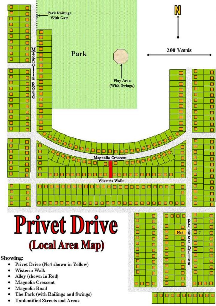
General Notes to the Local Area Map
The Local Area Map of Privet Drive is based upon research into similar residential areas of North Surrey and elsewhere in the United Kingdom. Most of the distances used are fairly certain and the actual orientation of number four is already defined. This suggested layout is only one of several that are possible. Privet Drive could (with its correct orientation) be positioned in any of the four corners of this map; and number four, itself, could lie to the northern or southern end of the street. However, from both logic and “gut-feeling” I believe that the map shown presents the most likely option possible.
As usual the map uses both Canon Facts from the books and some Logical Deductions, thus:
Facts
Privet Drive:
Number four faces east. (General)
Privet Drive has twenty or so houses. (twelve street lights PS1)
Number four is opposite Number seven, as shown. (OP1)
Privet Drive is NOT a cul-de-sac. It has two ends with corners (PS1)
Surrounding Area:
All the houses are similar large, square houses. (General, OP1)
Wisteria Walk is two streets away from Privet Drive (PS2).
Magnolia Crescent is “several streets away” from Privet Drive. (PA3).
There is an alley between Magnolia Crescent and Wisteria Walk. (General, OP1)
The alley is a “shortcut” to get from Magnolia Road to Privet Drive.
Magnolia Road is it the far end of Magnolia Crescent. (OP1)
Magnolia Road leads to the play park. (OP1)
The Park is large enough for Harry to be unnoticed on the unbroken swing when Big Dud and his Gang return across the park. (OP1)
Railings and a gate separate the park from Magnolia Road. (OP1)
Deductions:
Dimensions:
The size of the house plots is known; about 36 yards by 18 yards. So Privet Drive is a bit over 200 yards long. Using these sizes, Privet Drive can be placed on the map.
The scale also works: Harry was exhausted by the time he got to Magnolia Crescent entry to alley. No wonder: it’s not that far short of half a mile from Privet Drive.
It also works with the walk home to Privet Drive from the park. (length of Magnolia Road etc.)
Orientation of Magnolia Crescent:
The alley is halfway along the Crescent. Both ends of the Crescent are known. For it to be a valid short cut this can be the ONLY orientation.
Position of the park, etc.:
The park is to the far end of Magnolia Road. JKR states that Harry “crossed Magnolia Crescent and turned into Magnolia Road”. He is not stated as crossing Magnolia Road. And this side of the road fits best with following the gang back to the entrance to Magnolia Crescent”
Position of the swings is likely for Harry to be unnoticed.
Additional unidentified streets:
The street between Privet Drive and Wisteria Walk has to be there for it to be “streets away”.
The streets at the ends of Magnolia Crescent must be there. Where were the other members of Dud’s Gang going when they split up otherwise?