


Ottery St. Catchpole
and The Burrow
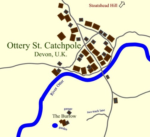
Ottery St. Catchpole is located in Devon, along the Otter River. Other towns along this river include Ottery St. Mary and Otterton. The town is relatively small. The Burrow is located near the village to the south [1] but is hidden by hills and trees. Most Muggles don’t even realize there is a house there. On the other side of the village from the Burrow is a fairly good-sized hill called Stoatshead Hill.
The Burrow includes a rather large, ramshackle house, a garage, a garden with a small lake, and yards surrounded by hedges.
The Diggory family lives in the general vicinity of Ottery St. Catchpole but several miles farther away. Other wizarding families living in the area are the Lovegoods and the Fawcetts.
The map above is not necessarily to scale, but it does show relative positions. The paddock used by the Weasley boys to practice Quidditch is not shown, but it seems logical that it would be located near the house but farther from the town. It is hidden from the Muggles by an orchard.
(Ginny also used it, of course, but her brothers wouldn’t let her play Quidditch with them as a youngster. She had to break into the family broomshed and take out her brothers’ brooms in turn from the age of six until after her fourth year, when they finally got a clue that she could play after she joined the Gryffindor team.)
1 – We know that The Burrow is to the south of the village from GF6. As the Harry and the others were walking from the Burrow toward town on their way to Stoatshead Hill, they saw that dawn was just beginning to their right. In July, the sun rises in the east-south-east, so they must have been walking more or less north to get to Ottery St. Catchpole from the Burrow.